A stroll around Silver Spring
In 1984, we moved to Silver Spring, Maryland, settling into an apartment right up against the boundary line with Washington, DC. Recently, I had an occasion to visit again and took the opportunity to set out on a walking tour around our old haunts in the downtown.
Silly springs?
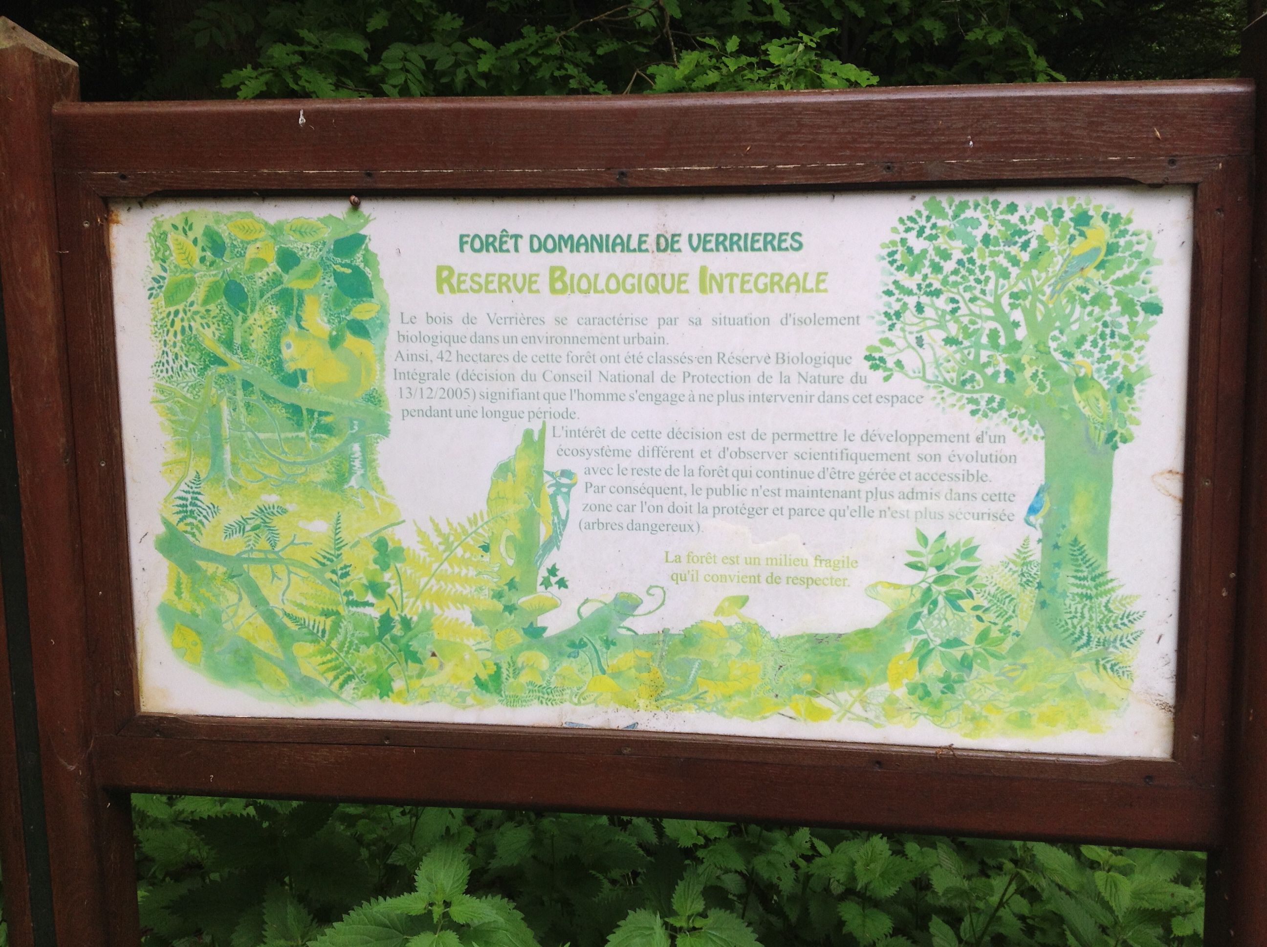
Our home was right around the corner from the site for which the town was named: the Silver Spring. Although the town is often called Silver Springs (and, on rare occasions, even “Silly Springs”), its actual name refers to a singular spring. The spring still exists on the edge of town in a small patch of green called Acorn Park. The poor spring struggles on, forlorn and neglected, producing just a tiny bit of humidity. In the decades since we moved away, developments and paving all around have cut off the replenishment of its aquifer and nowadays the Silver Spring is nearly dry.

The Silver Spring
According to the historical marker on the site, the spring was discovered in 1840 by Francis Preston Blair and daughter Elizabeth while touring the woods on horseback. They saw sunlight reflecting on mica sand in what turned out to be the spring and named it accordingly.
Wine and peace?
Silver Spring has been transformed in the years since we lived there. Downtown has been rebuilt with new housing, shops and commercial activity all around. On a recent Sunday part of the downtown was blocked off, vendors were selling food and kids were running around in a fountain that sprays water up from holes in the plaza pavement. Funky music played via a PA system and the atmosphere was festive.
Further on I came to an area where there has been an influx of Ethiopians. Although it is near downtown, parts of it have some resemblance to Addis Ababa with signs in Amharic and passersby conversing fluently in the language. Ethiopian flags, coffee and food are all around. The Addis Ababa Restaurant on Fenton Street has a good reputation. However, on my visit this weekend, I had another destination in mind.
I continued my walking tour of our old neighborhood and, based on a recommendation from local friends, wound up in the Adega Wine Cellar and Cafe. ( Sadly now closed, Feb. 2017.) The cafe serves up some interesting sandwiches and I had quite a decent crabcake. As it was a hot and humid day, I parked myself at a table in the air conditioning to sketch and enjoy a glass of Koina Riesling. I received a generous pour and savored the cool, refreshing wine, which had a nice acidity, with a hint of citrus and sweetness on my palate.

The Velvet Devil and a few other selections at the wine shop
While sketching, I was intrigued by the wine selection on the shelves around me, including a bottle labelled The Velvet Devil (which I placed on my agenda to try on a future visit). Although the shop is not particularly large, Adega’s has an interesting range of wines with selections that appear to offer good values from key wine regions around the world.
On a lazy Sunday afternoon, Adega’s turns into a kind of wine bar as folks come in for a glass and conversation. Next to me sat a few young Frenchmen quaffing a bottle of a big red. I enjoyed hearing their banter blend with the Spanish, English and Chinese being spoken by some others around. It seemed that although these folks were quite diverse, they would all agree on at least thing: a cool glass of wine on a hot day was a splendid idea.

Stop Sign – Takoma Park, MD
Setting out to continue my walk, I had a feeling that perhaps there was some hope after all for most folks around this world to get along, at least as long as the supply of Koina Riesling and big red wines holds out. As I headed back to my friends’ home in Takoma Park, a stop sign gave me some further advice for helping along the cause of peace: STOP EVIL. Makes sense to me!
Map of Silver Spring